


How to Use Coordinate Systems for Civil 3D Projects
Consider grid projection, ground projection or no projection when determining GIS, CAD data.
Civil 3D TutorialsMORE >>
How to Use Coordinate Systems for Civil 3D Projects
Consider grid projection, ground projection or no projection when determining GIS, CAD data.
Civil 3D Tutorials
Woodwork for Inventor Hardware Library
Place components into assembly exactly as placed in Inventor, constrain them in place before running W4I sculpt tool that cuts required shape into all mating parts.
Autodesk Inventor Tutorials
Precise mathematical language that describes form, orientation, location of various features on part.
Autodesk Inventor Tutorials
AutoCAD Plant 3D: Vendor Equipment Models
Tips to work with equipment models, specify connection information to simplify designs, bring them into Plant 3D through Inventor’s BIM Exchange environment.
AutoCAD Plant 3D Autodesk Inventor Tutorials Tutorials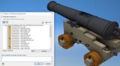
Checking Inventor Drawings Into Vault
Invoke check-in command in Inventor, press settings button to include parents in relationships tab.
Autodesk Inventor Autodesk Vault Tutorials
AutoLISP: Selecting-Gripping Objects by Handle
Avoid entering handle of style-based override, as there is no graphical object which can be gripped, SSFIRSTSET function will throw error, crash routine.
AutoLISP Tutorials

AutoCAD Plant 3D: Sharing Catalogs in Your Organization
Invoke PLANTMODIFYSHAREDCONTENTFOLDER command from AutoCAD Plant 3D’s command line on each workstation to move content to new location.
AutoCAD Plant 3D Tutorials
Follow